In my last post, I mentioned how "small" Dell City was and how far away the next town was and how I would not like living in a place like that.
I feel like we live "in the country", sort of. Our county is an area of 859 square miles, has a population of over 52,000 and the county seat, Canton, has a population of 3500+ and there are several more small towns, settlements, and random farms/ranches abound in our county, but it is definitely not crowded or over-populated. Our city friends think we live out in the "boonies", I'm sure!
By comparison, Dell City (pop. 365), where we had lunch yesterday, is in Hudspeth County which is an area of 4,572 square miles and the entire county only has 3,337 folks. Its county seat is Sierra Blanca (pop. 553). That means there are acres and acres and miles and miles of nothing!
Guadalupe Mountains National Park is in Culberson County which has an area of 3,813 square miles, and the entire county has only 2,290 folks living there! Not only that but 2,063 of those folks live in the town of Van Horn which is the county seat! That only leaves 227 individuals living in all the other 3,000+ square miles! Oh my! Living that remotely is not for me. Takes a special kind of folks to inhabit the vast areas of far west Texas! It goes to show you that there is something for everyone here in Texas! Texas has beautiful beaches, and majestic mountains, austere desert landscape, and almost every kind of topography and landscape in between.
We awoke to a gorgeous sunny day in El Paso this morning at the Candlewood Suites. Last evening, after arriving here at the hotel, we walked next door to a Wal*Mart and purchased food for breakfast and dinner for our time here at the hotel, since we have this nice kitchen area in our room.

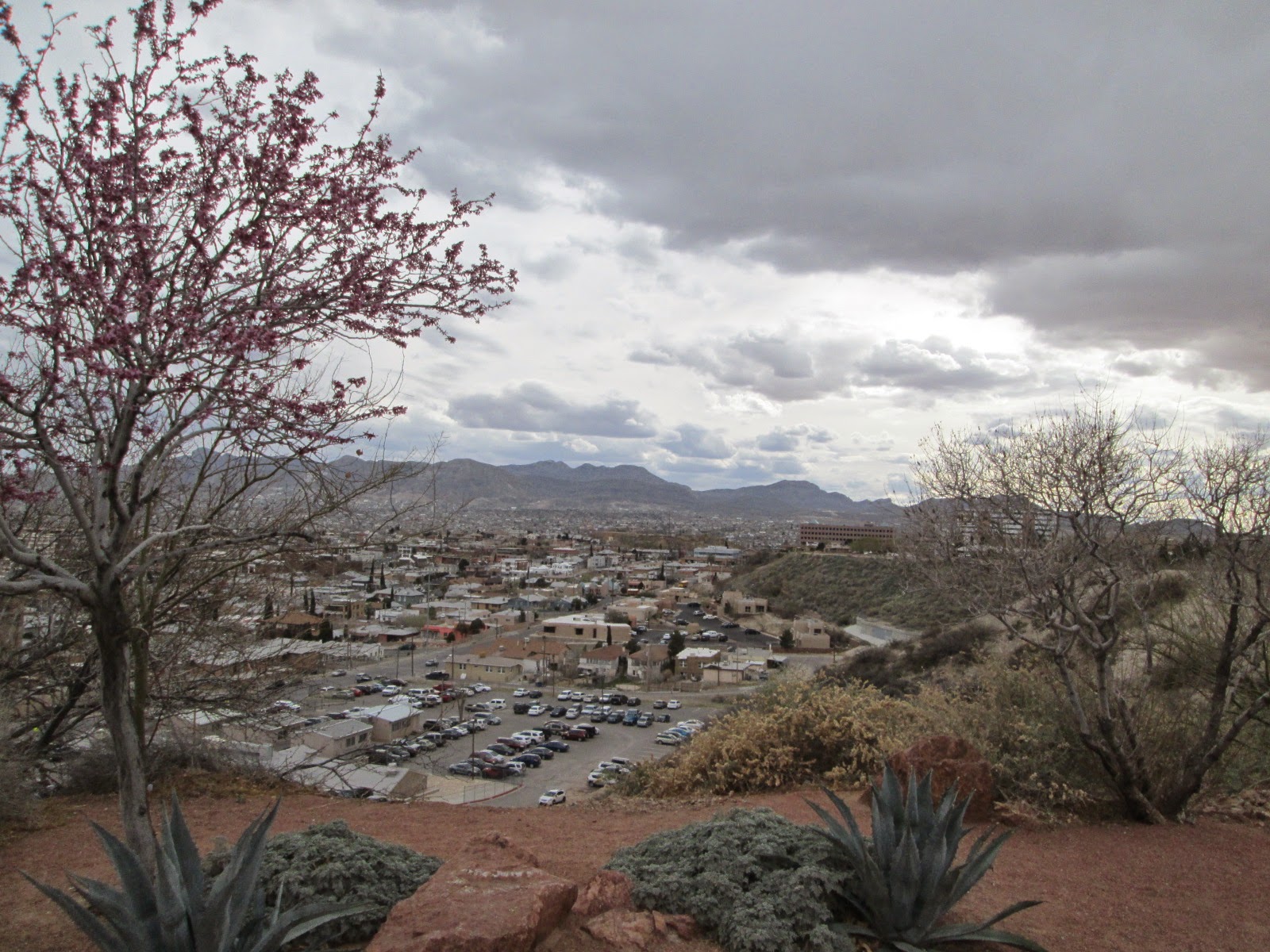
After breakfast in our room, we drove a scenic route thru some north El Paso neighborhoods on our way to McKelligon Canyon.

We were disappointed that the Wyler Aerial Tramway was closed for repairs/maintenance. The Tramway's airborne Swiss gondola glides to the top of Ranger Peak inside the Franklin Mountains State Park, for a mile-high view of Mexico, New Mexico, and the city of El Paso!


This squatty fat cactus caught my eye.

At the end of the park road was a great viewing area of the Rio Grande valley and the city of El Paso. BooBoo could not resist just hanging out and enjoying the view!

Next, we drove the short distance to the National Border Patrol Museum, stopping along the way at this historical marker on Smugglers Pass. Fusselman Canyon Fault, a natural cut into the Franklin Mountains has served for centuries as a natural corridor for the movement of people, goods and livestock between the river valley to the west and the desert basin to the east. At the end of the nineteenth century, even though El Paso was a booming town, the outlying areas were still plagued with frontier conditions....cattle rustlers and horse thieves....resulting in a man named Charles Fusselman being deputized on April 17, 1890 to aid in the hunt and capture of a group of these renegade thieves, and later being shot to death in a gun battle at the camp of the cattle rustlers near this canyon, which is named in honor of Fusselman.

The National Border Patrol Museum first opened its doors to the public (free admission) in 1985, and is on the northern edge of El Paso. The Museum (the only one of its kind in the United States), promotes the proud history and traditions of the U.S. Border Patrol, tracing the Patrol from the Old West to the challenging world of today.


This beautifully painted framed mural, depicting Border Patrol Agents working in the harsh desert environment, almost completely covers one entire wall!


Amazingly, this homemade smuggler's boat used to ferry people who are attempting to enter the U.S. illegally across the Rio Grande, utilized two truck hoods, pieced together in the middle with other vehicle body parts!

A variety of knives and other weapons found on folks fleeing from Mexico....

On September 19, 2007, this four-wheeled cart was found hanging from the steel girders under the 200 foot long Bridge of the Americas at El Paso. Attached to a yellow rope, the cart was pulled back and forth loaded with illegal contraband or people from one side of the border to the other! Incredible ingenuity and resourcefulness!

When we first saw these two captured motorcycles, we assumed they were from the 1930's? NO! These crudely adapted bikes were seized in the 1990's!

My husband, playing the part of a border patrol agent!

After leaving the National Border Patrol Museum, it was time for lunch. Time to try out a "new" taco location! Several years ago, Texas Monthly Magazine published an article "63 Tacos You Must Eat Before You Die". I am still carrying that article around in my purse, and over the years we have been to many of the places listed in that article sampling suggested tacos, and we have yet to be disappointed. So we headed to downtown El Paso to Tacos Santa Cecelia to try the recommended "Six-Pack-Combo" (we had 3 beef/3 pork). Santa Cecelia occupies a no frills concrete building resembling a fifties burger joint inside and a fifties fallout shelter outside! But look at how the meat is being cooked over an open fire on an upright rotisserie! Good tacos!


We then headed to Fort Bliss. Thought we would check out the base Museum.

However, we were allowed to go into the Fort Bliss National Cemetery. Very sobering to see the thousands of white headstones memorializing the brave and courageous men and women who have died serving our country.


Next we drove just outside of El Paso to Hueco Tanks State Park.


We then drove back into El Paso to check out Scenic Drive which we accessed from Rim Road.


Our last stop of the day was at the El Paso Saddleblanket World Headquarters!


...was any and every thing you could possibly imagine...
from souvenirs to hand-woven wool rugs to southwestern accessories...plus quite a collection of very old saddles (not for sale)...

...to home furnishings...

...to the owners', Dusty & Bonnie Henson, own private collectibles!

You name it and they had it! Two huge buildings covering about three acres...a shoppers'/tourists' paradise!
Tom bought Dusty's book "A History of the El Paso Saddleblanket Company" (an excellent read!) by the owners, Dusty and Bonnie Henson. A very fascinating book about the life of a "born trader", Dusty Henson, who began pedaling saddleblankets from the back of a pickup truck alongside the road, and has now built his company into a thriving worldwide business!
Tomorrow we leave El Paso and head toward San Antonio, Texas!
Gazing at the Franklin Mtns and the aerial tram from my barracks at Fort Bliss back in 1968, was a visual escape from the rigors of Basic Combat Training. This was a tumultuous period in our country's history......assassinations of MLK and RFK, Vietnam protests, etc....and in a few short months I was to be flown overseas to enter the fray.
ReplyDelete